Mapa Moho
|
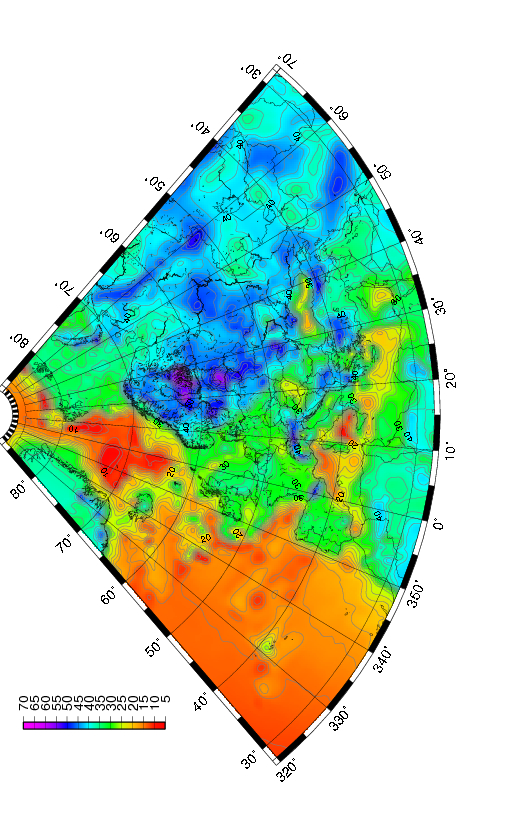
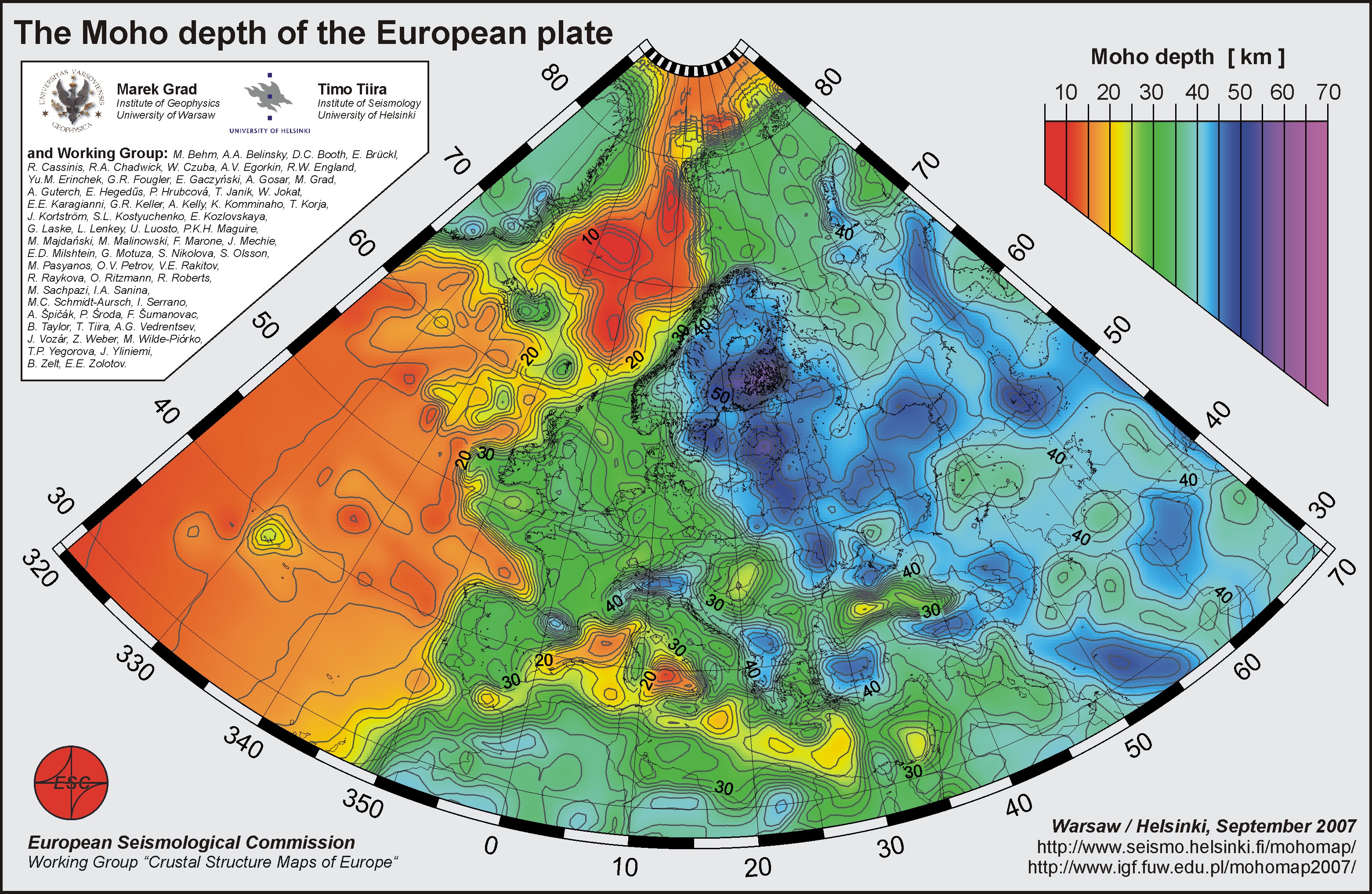
Summary The European plate has a 4.5 Gy long and complex tectonic history. This is reflected in the present day large scale structures. The new digital Moho depth map is compiled from more than 250 data sets of individual seismic profiles, 3D models obtained by body and surface waves, receiver function results, and maps of seismic and/or gravity data compilations. We have compiled the first digital, high resolution map of the Moho depth for the whole European plate extending from the Ural Mountains in the east to mid-Atlantic ridge in the west, and from the Mediterranean Sea in the south to the Barents Sea and Spitsbergen in Arctic in the north. In general three large domains within European plate crust are visible. The oldest Archean and Proterozoic crust has thickness 40-60 km, continental Variscan and Alpine crust has thickness 20-40 km, and the youngest oceanic Atlantic crust has thickness 10-20 km. An estimation of uncertainty has been computed for the area of the Moho map. # ESC Working Group comprises: M. Behm, A.A. Belinsky, D.C. Booth, E. Brückl, R. Cassinis, R.A. Chadwick, W. Czuba, A.V. Egorkin, R.W. England, Yu.M. Erinchek, G.R. Fougler, E. Gaczyński, A. Gosar, M. Grad, A. Guterch, E. Hegedűs, P. Hrubcová, T. Janik, W. Jokat, E.E. Karagianni, G.R. Keller, A. Kelly, K. Komminaho, T. Korja, J. Kortström, S.L. Kostyuchenko, E. Kozlovskaya, G. Laske, L. Lenkey, U. Luosto, P.K.H. Maguire, M. Majdański, M. Malinowski, F. Marone, J. Mechie, E.D. Milshtein, G. Motuza, S. Nikolova, S. Olsson, M. Pasyanos, O.V. Petrov, V.E. Rakitov, R. Raykova, O. Ritzmann, R. Roberts, M. Sachpazi, I.A. Sanina, M.C. Schmidt-Aursch, I. Serrano, A. Špičák, P. Środa, F. Šumanovac, B. Taylor, T. Tiira, A.G. Vedrentsev, J. Vozár, Z. Weber, M. Wilde-Piórko, T.P. Yegorova, J. Yliniemi, B. Zelt, E.E. Zolotov. If you find the moho map useful, please cite: Grad, M., Tiira, T., and ESC Working Group, 2009. The Moho depth map of the European Plate, Geophys. J. Int. (2009) 176, 279-292, doi: 10.1111/j.1365-246X.2008.03919.x. |

| Downloadable files: Pliki do pobrania: Moho depth [km] in 0.1 x 0.1 degree grid, grd (netCDF) file from GMT4.0 Moho depth uncertainty [km] in 0.1 x 0.1 degree grid, grd (netCDF) file from GMT4.0 To make easily Moho depth or uncertainty grid into ArcGis (9.2) layer file: To make easily Moho depth or uncertainty grid into ArcGis (9.2) layer file: A0-size postscript and PDF plots of the Moho map A4-size postscript, jpg, tiff and PDF plots of the Moho map mapa Moho w rozmiarze A4 (jpg i tiff) z tytułem i legendą Europe_moho_depth_2007_a4_info.jpg Europe_moho_depth_2007_a4_info.tif.gz The Moho map covers area lat 28N-86N, lon 40W-70E. Please, send any comments or questions about the map to Marek Grad mgrad@mimuw.edu.pl or Timo Tiira timo.tiira@helsinki.fi |
Data zmiany strony 19 czerwca 2018 12:06